
CHALLENGE
Given the recent uptick in crime in and around campus, how can CMU enables students and faculty the ability to safely commute to and from campus.
OUTCOME
A two-way system that addresses the most pressing concerns with the existing CMU shuttle system.
As members of the Carnegie Mellon community, we often have to travel on and around the vicinity of campus multiple times daily. Be it for class, homework, social events or meetings, such activities often occupy large blocks of time and require students to return home very late each night. Many students, include myself, don't feel completely safe commuting home unaccompanied especially with recent episodes of crime occurring around campus. This is a sentiment that is shared not only by students, but by the many faculty that commute via foot or bike each day.
While CMU does have a few measures, namely the CMU Escort Shuttle, in place to address this concern, it has not alleviated this major student concern. Using a human-centered approach, my partners (Miranda Luong and Rachel Lee) and I designed a proposal that would improve this system
I was responsible for visuals (e.g. maps and assets), guerrilla interviews, and wireframing/user interfaces.
In order to garner a better understanding of the people and their differing kinds of involvement in CMU’s public safety, we began by creating experience diagrams and territory maps. We were then able to pinpoint the CMU Escort Shuttle, our school’s sole commuter safety program, as the service to examine and its off-campus student users as the demographic to consult.


By experiencing the shuttle first-hand, we gained a better understanding of the formal and informal procedures when riding the shuttle. We observed the shuttle’s passengers and drivers, their interactions with one another and noted the artifacts involved as well.

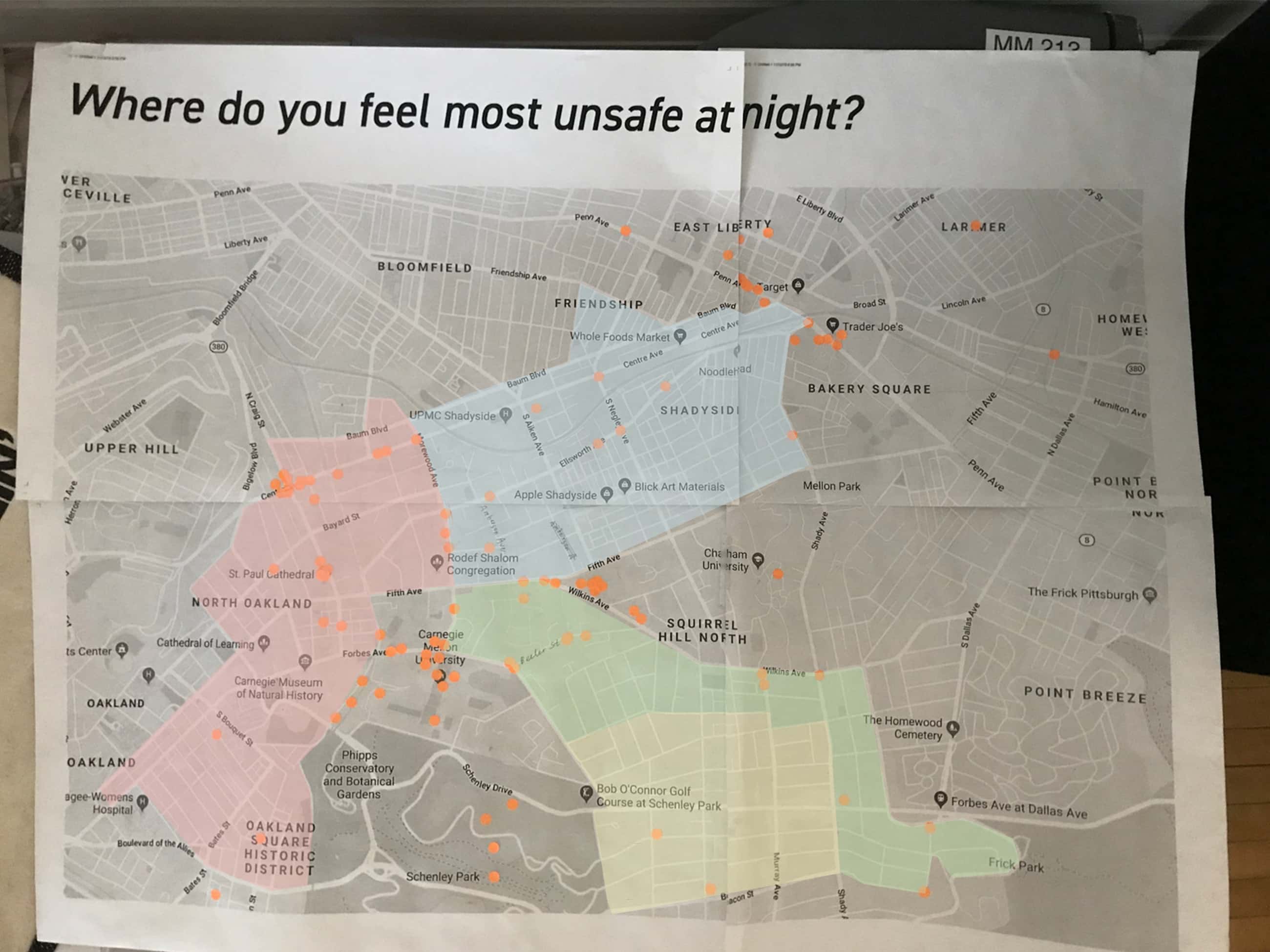
We returned to the same common spaces and conducted interviews with students living off-campus. Our questions were centered around their familiarity with the service and possible issues they, as users and non-users, had with the service. All together, we collected 126 unique responses. Shown below is a sample of 25.

Early research and first-hand observation of the CMU Escort Service told us the escort shuttle ran through designated zones within Pittsburgh at night. Faculty and students are driven to their off-campus housing destinations so long as it was within the zone of operation. Stationed in university common areas, we invited off-campus residents to pinpoint where they felt most unsafe o their nightly commutes. By cross referencing this data with the shuttle’s areas of operation, we were then able to reason out the possibility that an issue lies within the boundaries of the shuttle’s operation.
01/ Perception
The escort shuttle suffers from a poor reputation in part because the university provides inadequate information about the escort service and its key features.
02/ Waiting Period
Live tracking does not inform riders of the exact times when the shuttle will arrive at pickup stops. This leaves riders with no choice but to wait for extended periods.
03/ Performance
The shuttle can take upwards of an hour to deliver passengers home. Many riders blamed poor route planning as the current system relies solely on driver intuition.
04/ Drivers
Riders note that they often felt uneasy or even unsafe because they did not know who was driving them home.

01/ ID Cards
Since ID cards are already embedded with the cardholder's residence information, students and faculty will scan their IDs instead of verbally informing drivers of their destinations and presenting proof of university affiliation.
02/ Efficient Route Planning
After the system retrieves each rider's home address, an algorithm will determine the most efficient drop off route to expedite travel time. This information is relayed to the driver's GPS.
03/ Live Tracking
Estimated arrival time to pickup stops will be calculated and viewable alongside the shuttle's most updated location via the existing mobile app for more efficient trip planning. Route information will provided to the riders via a screen on the shuttle and the mobile app.


